Information window - press J or ? to to open, ESC to close
Image Size * 0 1 5 10 12 buttons on top of page represent photo heights of:40px 133px 500px 1000px and 1200px * There are 3 modes of display ( Z ) for a single photo:1)normal, 2)background stretch, and 3)height or width stretch Navigation - single photo * Click mouse in left/right part of the screen* Use +/- 5 10 20 50 buttons to skip forward/backward * Use right/left keyboard arrow keys * Use keyboard keys eg N =New Photos, A =Arizona |
Settings window - ESC to close
| Coming soon |
|
|

Navigator
 1.* Photos *
 |
2.Best/Pano/Minis |
3.My Adventures |
4.Travels |
5.Questions/Answers |
6.Prog |
7.Maps |
8.CoolGeographic
1.Arizona |
2.Colorado |
3.Utah |
4.California |
5.Nevada |
6.New Mexico |
7.Wyoming |
8.Montana |
9.Ontario |
10.Greece |
11.SlovakiaColorado
ALL |
1.Crystal Lake |
2.Red Mountain Pass |
3.Mount Sneffels |
4.San Juan Mountains |
5.Last Dollar Road |
6.Owl Creek Pass |
7.Ouray |
8.Silverton |
9.Molas Pass |
10.Maroon Bells |
11.Mount Sopris |
12.McClure Pass |
13.Crested Butte |
14.Kebler Pass |
15.Ohio Pass |
16.Blue Mesa |
17.Independence Pass |
18.Aspen |
19.Twin Lakes |
20.La Plata Peak |
21.Mt Elbert |
22.Mt Massive |
23.Mt Yale |
24.Mt Princeton |
25.Leadville |
26.Fremont Pass |
27.Eisenhower Tunnel |
28.Silverthorne & Frisco |
29.Loveland Pass |
30.Mt Evans |
31.Mt Bierstadt |
32.Long's Peak |
33.Rocky Mountain National Park |
34.Boulder |
35.Clear Creek by Golden |
36.Miner's Candle |
37.Pike's Peak |
38.Garden of the Gods |
39.Rampart Range Rd |
40.Sedalia |
41.Wilkerson Pass |
42.Grand Junction |
43.Mesa Verde |
44.Durango |
45.Wolf Creek Pass |
46.Blanca Peak |
47.Del Norte to Trinidad |
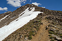
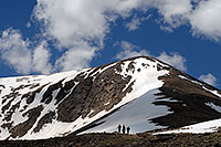
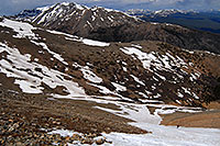
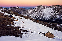
48.Great Sand DunesLa Plata Peakelev: 14,336 ft Sawatch 5th tallest fourteener |
|
"Silver" peak in Spanish, after silver deposits were discovered in early 20th century. Hiking: (Highway I-82) 4.75 miles, 4,500 ft gain First Trail starts from the north side, along Independence Highway I-82 and follows the northern ridge which divides La Plata basin from La Plata Gulch.Second Trail starts in Winfield, to the south of the peak and leads through a marshy basin and up a headwall. |
Warning: Undefined variable $groups in /var/www/robertbody/html/colorado/la-plata-peak.html on line 47
Warning: Undefined variable $photos in /var/www/robertbody/html/colorado/la-plata-peak.html on line 47
Warning: Undefined variable $breaks in /var/www/robertbody/html/colorado/la-plata-peak.html on line 47
 |
| Colorado > Mt Elbert |
 |
| Colorado > Mt Massive |
 |
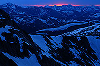
| Colorado > Independence Pass |
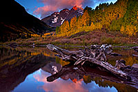 |
| Colorado > Maroon Bells |
 |
| Colorado > Mt Evans |
 |
| Flowers > Colorado Wildflowers |
Notes:
• A hike of 4hours uphill by many... but pretty views along the way so that it took me 9hours and still i didn't reach the top at 6pm.
(In addition to stopping often to catch my breath.) And walking down a mountain without a trail - not a good idea. Merging in the dark with a trail in the woods
- not a good idea. 15 hour hiking day, last 6hours without water, lost bushwacking through river-bushes in the dark for 1.5 hours -- can't wait to go back, really
 - next time I will make other mistakes, not same ones.
• www.14ers.org/page.php?pname=peaks/sawatch/laplata - info
.colorado.la-plata-peak
|