Information window - press J or ? to to open, ESC to close
Image Size * 0 1 5 10 12 buttons on top of page represent photo heights of:40px 133px 500px 1000px and 1200px * There are 3 modes of display ( Z ) for a single photo:1)normal, 2)background stretch, and 3)height or width stretch Navigation - single photo * Click mouse in left/right part of the screen* Use +/- 5 10 20 50 buttons to skip forward/backward * Use right/left keyboard arrow keys * Use keyboard keys eg N =New Photos, A =Arizona |
Settings window - ESC to close
| Coming soon |
|
|

Navigator
 1.* Photos *
 |
2.Best/Pano/Minis |
3.My Adventures |
4.Travels |
5.Questions/Answers |
6.Prog |
7.Maps |
8.CoolGeographic
1.Arizona |
2.Colorado |
3.Utah |
4.California |
5.Nevada |
6.New Mexico |
7.Wyoming |
8.Montana |
9.Ontario |
10.Greece |
11.SlovakiaArizona
ALL |
1.Havasu Falls |
2.Superstitions |
3.Sedona |
4.Grand Canyon |
5.Page |
6.Horseshoe Bend |
7.Marble Canyon |
8.Vermilion Cliffs |
9.Kayenta |
10.Upper Antelope Canyon |
11.Lower Antelope Canyon |
12.Canyon X |
13.Saguaro Lake |
14.Lake Havasu |
15.Bill Williams River |
16.Lake Pleasant |
17.Snowbowl |
18.Humphrey's Peak |
19.Four Peaks |
20.Red Mountain |
21.Santa Rita Mountains |
22.Box Canyon |
23.Elephant Head |
24.Green Valley |
25.Santa Catalina Mountains |
26.Tucson Mountains |
27.Saguaro National Park |
28.Picacho Peak |
29.Queen Valley |
30.MiscSedona
ALL |
1.Schnebly Hill Road |
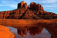
2.Cathedral Rock |
3.Thunder Mountain (Capital Butte) |
4.Misc Sedona 2000-2003Sedonaelev: 4,000 ft |
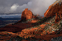
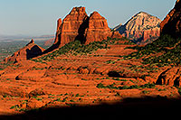
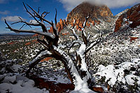
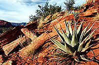
| Sedona Arabelle Miller Schnebly (1877-1950), wife of the city's first postmaster. Hiking: Schnebly Hill, Soldier's Pass, Dry Creek, Cathedral Rock Red Rocks of Sedona , the stunning array of red sandstone formations, glow orange and red during sunrise and sunset. The famous red rocks are formed by a layer of rock known as the Schnebly Hill Formation, a thick layer of sandstone found only in the vicinity and deposited during the Permian Period (300 million years ago). |
 |
| 1. Schnebly Hill Road |
 |
| 2. Cathedral Rock |
 |
| 3. Thunder Mountain (Capital Butte) |
 |
| 4. Misc Sedona 2000-2003 |
.arizona.sedona
|